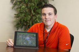
Citizen Potawatomi Nation employee Zach Davis remembers his childhood family trips, eagerly surveying road maps as he navigated their journeys.
“I really like looking at maps and making heads or tails, geographically, why things are where they are,” he said.
The fascination carried into college, where he dropped his history teaching major at East Central University when he learned the school had a cartography department.
“That’s when I took off,” he said. “I saw myself more in that field, so I decided to go that route,” though he didn’t abandon his interest in history.
“That’s actually one of the main reasons why I applied for this job,” he said. The Tribe hired him in December as a geographic information specialist (GIS). “I think, historically, that’s something that fascinates me — mapping movement of when the tribes were relocated by the federal government, for example. It’s always interesting, and I think Tribal members themselves are interested to see the migration routes that they took.”
Today, Davis is helping chart the Nation’s future. “I map various features for them, such as their property, their utilities,” he said. “We do quite a bit of environmental assessment since the majority of our projects with the Environmental Department are through grants. So, we constantly have to update floodplain management, elevation. We always have to have updated topography.”
Properties change (and Davis helps update those) regularly. Then there are land features, underground utility lines, topography, communication lines — all vital data for Tribal planning and development, housing, construction and more.
“I’ve worked on improving field application because that was a big thing with a lot of the crews — they didn’t have anything out there they could just pull up and use,” he said.
In April, he started testing a mobile application — a program that workers can upload and use out in the field — that combines multiple data sets into an easy-to-use resource. When in the field, the mobile device’s GPS locates where they are and where they need to be.
He and members of CPN’s Information Technology team are creating “data dictionaries” using high-tech Trimble GPS surveying devices. They are added to data Davis receives from the Tribe. Then, it’s uploaded to the app, which resembles Google Maps in many ways. Users click on any point on a map, bringing up layers of necessary information.
In May, select CPN Public Works, Environmental Health and Construction Department employees started using apps customized to their needs. Some will have the programs installed on truck-mounted laptops by July.
Granted, Davis didn’t invent data collection, but he’s helping develop easier, more efficient ways to utilize it.
“The beauty of it is that we’re constantly growing as a Tribe — utilities, properties — so this application will never be complete,” he said. “It’ll constantly move forward.”